


Can you trade options in Vanguard Roth IRA? Discover the answer now
Trading Options in Vanguard Roth IRA: What You Need to Know If you’re considering opening a Vanguard Roth IRA and want to know if you can trade …
Read Article
In recent years, the emergence of wireless technologies has revolutionized the way we communicate and interact with our surroundings. One of the key challenges in these wireless networks is estimating the location of mobile devices accurately and efficiently. Location estimation has a wide range of applications, including asset tracking, location-based services, and enhanced navigation.
RSSI, or Received Signal Strength Indicator, is a commonly used parameter for estimating the distance between a mobile device and access points in wireless networks. RSSI-based location estimation methods utilize the RSSI measurements collected from multiple access points to determine the location of a mobile device. These methods typically rely on signal propagation models and statistical techniques to infer the position of the device.
This article aims to provide an in-depth understanding of RSSI-based location estimation methods. It explores the underlying principles of RSSI measurements and their relationship to distance estimation. Furthermore, it discusses different signal propagation models and statistical techniques used in RSSI-based localization algorithms. It also highlights the limitations and challenges faced by these methods, such as multipath interference and environmental factors.
By gaining a deeper understanding of RSSI-based location estimation methods, researchers and engineers can improve the accuracy and reliability of location-based services in wireless networks. This article serves as a comprehensive guide for anyone interested in the field of location estimation and its applications in various industries.
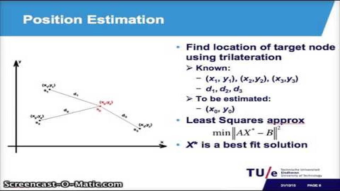
One common method for estimating the location of a device using Received Signal Strength Indicator (RSSI) measurements is trilateration. Trilateration relies on the principle that the RSSI decreases with increasing distance between the device and the access points (APs).
In trilateration, the location of the device is estimated by intersecting circles or spheres centered around the known locations of three or more APs. Each circle or sphere represents a possible location for the device, and the intersection point(s) indicate the most likely position. To perform trilateration, the distance between the device and each AP must be known.
Distance estimation can be done using RSSI measurements and a propagation model, which relates the RSSI to the distance. Different propagation models can be used, such as the log-distance path loss model or the Free Space Path Loss (FSPL) model. These models take into account factors such as signal attenuation, interference, and environmental conditions to approximate the distance between the device and the AP.
Once the distances between the device and the APs are estimated, trilateration can be performed using mathematical algorithms, such as the Taylor series expansion or the least squares method. These algorithms calculate the intersection point(s) of the circles or spheres, providing an estimate of the device’s location.
It’s important to note that trilateration using RSSI has limitations. It relies on accurate distance estimation and assumes a relatively static environment. Factors such as multipath interference, signal fluctuations, or changes in the environment can affect the accuracy of the location estimation. Additionally, trilateration may not be feasible in certain scenarios where the number of APs is limited or their locations are not known.
Despite these limitations, trilateration using RSSI remains a widely used method for location estimation in many applications, such as asset tracking, indoor positioning, and wireless sensor networks. It provides a relatively simple and cost-effective way to estimate the location of devices based on RSSI measurements.

In fingerprinting-based RSSI location estimation, a database of signal strength measurements at different locations is created, known as a “fingerprint database”. This database is built by collecting RSSI readings at various locations in the target area. These readings are typically collected using a mobile device with a wireless network card.
Once the fingerprint database is created, the location estimation process can begin. This method involves comparing the RSSI readings obtained from the target device with the fingerprint database to determine the most likely location of the device.
The location estimation process consists of several steps:
Fingerprinting-based RSSI location estimation has been widely used in indoor localization systems. It can provide high accuracy in environments with stable signal characteristics, such as buildings with fixed access points. However, it may suffer from accuracy degradation in dynamic environments with changing signal conditions.
Read Also: Beginner Guitar: The Top 3 Chords Every Musician Should Learn
Overall, fingerprinting-based RSSI location estimation is a powerful method that can be used to accurately estimate the location of a mobile device based on RSSI measurements. It is widely used in various applications, including asset tracking, indoor navigation, and location-based services.
Machine learning approaches have shown promising results in RSSI-based location estimation. These methods utilize machine learning algorithms to learn the relationships between RSSI values and the corresponding locations. By training the models with a large dataset of RSSI measurements and known location coordinates, the models can then predict the location based on new RSSI measurements.
Read Also: PKO Bank address in Poland: Find out where to locate PKO bank branches
One popular machine learning approach is the k-nearest neighbors (KNN) algorithm. In this method, the algorithm first computes the distance between the new RSSI measurements and the training dataset. It then selects the k nearest neighbors based on the distance and assigns the location based on the majority vote among these neighbors. KNN has been successfully applied to RSSI-based location estimation and has shown good accuracy in various scenarios.
Another machine learning approach is the support vector machine (SVM) algorithm. SVM aims to find the hyperplane that best separates the training samples into different classes, based on their RSSI values. The hyperplane can then be used to predict the location of new RSSI measurements. SVM has been widely used in RSSI-based location estimation and has shown good performance in different environments.
Deep learning is also being explored in RSSI-based location estimation. Deep learning models, such as convolutional neural networks (CNN) and recurrent neural networks (RNN), can learn complex relationships between RSSI values and locations. These models have shown promising results in various localization tasks and have the potential to improve the accuracy of RSSI-based location estimation.
Overall, machine learning approaches offer a powerful and flexible solution for RSSI-based location estimation. They can adapt to different environments and can handle noisy RSSI measurements. However, it is important to note that these approaches require a large amount of training data and may require significant computational resources for training and prediction. Additionally, the performance of these methods can be affected by factors such as the quality of the RSSI measurements, the distribution of training data, and the choice of machine learning algorithm.

| Pros | Cons |
|---|---|
| Can handle noisy RSSI measurements | Require a large amount of training data |
| Flexible and adaptable to different environments | May require significant computational resources |
| Show promising results in various scenarios | Performance can be affected by factors such as data quality and distribution |
In conclusion, machine learning approaches offer a promising solution for RSSI-based location estimation. These methods have shown good accuracy and have the potential to improve the performance of localization systems. However, further research is needed to optimize the training and prediction processes and to explore the combination of different machine learning algorithms for enhanced accuracy.
RSSI stands for Received Signal Strength Indicator. It is a measure of the power level of the received signal in a wireless communication system.
RSSI can be used for location estimation by measuring the signal strength of multiple access points and comparing them. The stronger the signal from an access point, the closer the device is to that access point.
Some limitations of RSSI-based location estimation methods include the variability of signal strength due to factors like interference, obstacles, and multipath effects. Additionally, the accuracy of RSSI-based methods can be affected by the distance between the device and the access point.
Yes, there are alternative methods for location estimation, such as using time of arrival (TOA), time difference of arrival (TDOA), or angle of arrival (AOA) measurements. These methods can provide more accurate location information, but may require specialized hardware or infrastructure.
RSSI-based location estimation methods can be improved by using techniques like fingerprinting, which involves creating a database of RSSI measurements at known locations and using it to match and estimate the current location. Additionally, advanced signal processing algorithms can be used to mitigate the effects of interference and improve accuracy.
RSSI-based location estimation method is a technique used to estimate the location of a device or object based on the Received Signal Strength Indicator (RSSI) of wireless signals.
RSSI-based location estimation works by measuring the strength of wireless signals from multiple access points or beacons and using this information to calculate the distance between the device and each access point. The device’s location is then estimated based on the distances to the access points.

Trading Options in Vanguard Roth IRA: What You Need to Know If you’re considering opening a Vanguard Roth IRA and want to know if you can trade …
Read Article
What is the Best Indicator to Filter Out Choppy Markets? Choppy markets can be frustrating for traders, as they lack clear trends and can result in …
Read Article
Methods to Minimize Losses in Binary Options Trading In the fast-paced world of binary options trading, it is crucial to understand how to effectively …
Read Article
Choosing the best MACD indicator combination When it comes to trading in the financial markets, having a reliable and accurate indicator is crucial …
Read Article
Understanding the Difference between GOOG and GOOGL Options Options trading can be a complex and daunting endeavor, especially when it comes to …
Read Article
Can you deposit foreign currency into HSBC UK? If you’re a customer of HSBC UK and you’ve recently returned from a trip abroad with leftover foreign …
Read Article


